
Finding Denton County Streets by Address
An address can be walked through several Denton County systems, but each system has a different job. The tax record provides an account, owner or mailing context, and property location. GIS identifies the parcel and its R number or X-ref ID. The deed index documents recorded interests tied to parties, legal descriptions, subdivisions, and dates. A historical directory may add a dated household lead. The sequence below keeps ownership, mapping, and household evidence from being mixed together.
- Normalize the current address and preserve any old spelling, direction, or street type supplied by a document or directory.
- Search TaxWeb by property location to identify the situs, then save owner mailing information as a separate field.
- Open the County GIS parcel layer, click the subject parcel, and record the R number or X-ref ID with its legal description.
- Search the County Clerk index by the current party, subdivision, legal-description term, or document number, then work backward through instruments.
- Compare a dated directory, map, permit card, or newspaper item only after the address and parcel bridge are documented.
A Denton street directory search can reveal a public property trail. It cannot turn a deed party or mailing address into an unsupported statement about who is presently at an address.
Denton County Street Directory Property Walkthrough
TaxWeb offers separate routes for owner name, owner address, and property location. Its help says owner-name searching uses last-first or last plus first initial. Owner address is the mailing address attached to the account. Property location is the actual situs and is searched with a number plus street name, without street type or direction. The form also provides account-type, active or inactive account, and paid or unpaid controls. These labels matter because a tax account can have a mailing address far from the parcel.
| Starting fact | Denton street directory action | Record to preserve |
|---|---|---|
| Full street address | Use TaxWeb property location, then compare DCAD and GIS | Situs, parcel ID, legal description, source date |
| Owner name | Use TaxWeb owner-name format, then verify the specific parcel | Account context and separately labeled mailing field |
| Subdivision or lot detail | Use GIS and then the Clerk’s PublicSearch index | Legal description and matching instrument |
| Historic street number | Compare directories, maps, address records, and the deed trail | Old form, modern form, evidence date, confidence note |
The Denton County TaxWeb search is useful for the initial distinction between the property location and the owner’s mailing field. Check the current portal help before assuming a search option has not changed.
Note: A property location identifies the parcel’s situs, while an owner mailing address identifies where tax correspondence is sent.
Denton County TaxWeb Mailing Fields
DCAD provides the structured parcel layer behind an address search. Its published schema includes property ID, owner name, mailing address lines, legal description, abstract or subdivision codes and descriptions, block, tract or lot, acreage, living area, year built, exemptions, city, school and special districts, and complete situs fields. The schema also separates certified value fields from physical or legal-description fields. It is a way to stabilize a parcel identity before moving into dated instruments.
One DCAD field needs a careful label: cad_zoning is a DCAD land-use field, not City zoning. Public downloads exclude confidential ownership and over-65 exemption material where the law requires it. Parcel geometry is updated or exported weekly, while owner data can lag during annual notice and appraisal-review work. A fresh page date and the field source belong in any research log.
- Parcel
- A mapped unit of land connected to a property ID and legal description.
- Situs address
- The actual property location, kept apart from a mailing address.
- Plat
- A recorded subdivision map that can help identify lots and blocks.
- Criss-cross directory
- A historical directory arranged by address, useful only for its dated entry.
The Denton Central Appraisal District is the official public entry point for current parcel and valuation access.
Denton County GIS Parcel Layers
Denton County GIS has maintained shared county information and cadastral data since 1995. The official property-identification procedure directs a user to turn on Layers, choose Parcels, and click the parcel. That click provides an R number or X-ref ID and parcel information. The procedure identifies layer groups for Parcels, Abstracts, City Limits, ISD, Sales, Address, Owner, Streets, and other public layers. These layers provide the map-to-record bridge for a Denton street directory search.
For a block-level review, select the subject parcel first and then inspect touching polygons. Record adjacent parcel IDs, legal descriptions, and map relationships. Query each parcel independently in DCAD rather than inferring people from a street or mailing field. County GIS can cross city limits and special districts, so a city name in an address does not decide the entire jurisdiction. GIS information is approximate and should not be used as a legal survey.
The Denton County GIS page links the Landmark Interactive Map, datasets, and address or precinct resources. The live viewer’s exact search controls were not captured, so use its current interface rather than relying on an assumed syntax.
Note: Map layers can establish parcel relationships and jurisdiction context, but they do not establish a survey boundary or a current household.
Denton County Street Numbers Through 1920
Old Denton addresses need a separate historical bridge. The Denton Public Library house guide identifies a citywide address renumbering in February 1920. A City historic survey describes a 1919 through 1921 program that used a grid, 300-foot blocks, 100 numbers per block, and 50 numbers on each side. These details explain why a directory address from before that work may not match a modern situs search, even when the street name seems continuous.
There is no universal conversion table in the research. Compare the old number with the street name, map, owner, subdivision or legal description, and deed chain. Keep three questions apart: whether it is the same parcel, whether it is the same street segment, and whether a named person is the same person. A current address search alone cannot safely answer any of those historical questions.
The City of Denton Addressing office assigns addresses inside city limits, typically following the county grid, after plats are filed or when an address is needed. Rural and unincorporated locations require county GIS and postal verification as well.
Note: Record old and current address forms separately until map, deed, or parcel evidence supports their relationship.
Denton County Street Renaming Records
Street names can change through a formal municipal process. The City ordinance says new names should preserve continuity and avoid conflicts. Existing renames require an ordinance. An application asks for the current official name, proposed name, date, map or location, requester name and property address, and the reason. The standards reference address and geographic naming practices, so a historical street research file should preserve both versions rather than silently replacing an old name.
Property owners representing more than half of the linear frontage on both sides may apply, and a governmental subdivision or agency may also be an applicant. That process is useful context for a change, but it does not create a claim about current households. For a city-limits address, request existing addressing or renaming records by street, address, date range, map, and department under the Texas Public Information Act. The City is asked for existing records, not a newly created roster.
The City street-renaming ordinance gives the official continuity and petition framework. Save the ordinance or application date with any street-name conclusion.
Denton County Clerk Deed Chain
Once the parcel is secure, PublicSearch can build the recorded chain. The County Clerk’s Quick Search accepts grantor or grantee terms, a subdivision, a document type or number, and recorded-date fields. It has date shortcuts and choices for index-only or index plus full-text OCR searching. Start with the current owner or known grantee, then look for a prior owner as grantor, legal-description terms, subdivision, block, lot, or a known instrument number. The house-history guide recommends this current-parcel-to-deed sequence.
Each instrument should be retained as its own record type. Warranty deeds, deeds of trust, releases, plats, easements, liens, assignments, and probate transfers can all appear in an address trail, but they do not mean the same thing. A chain of title is the sequence of recorded interests leading backward through time. A legal description often makes a stronger bridge than a street number when a parcel has been replatted or a street has changed.
The County Clerk PublicSearch index provides the verified quick-search interface for this work.
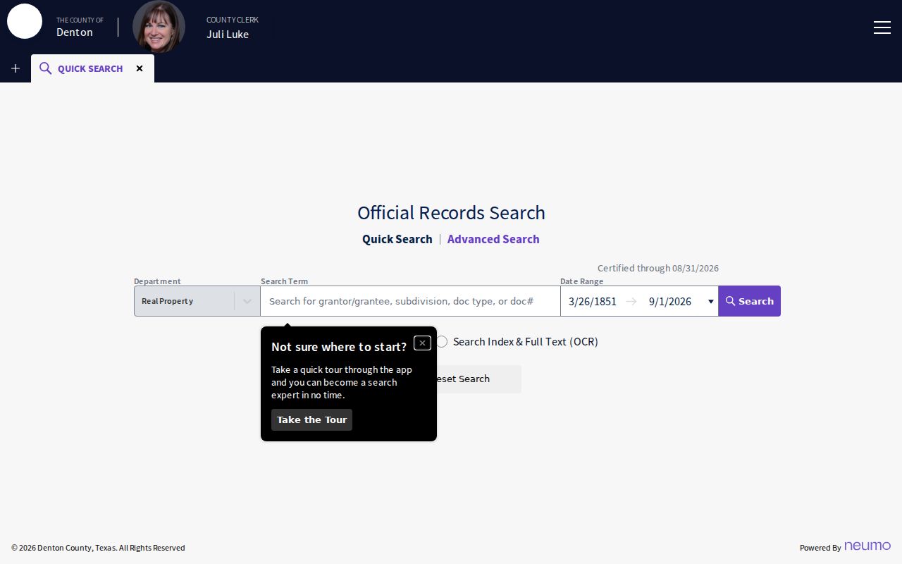
Record the instrument date, document number, grantor, grantee, type, legal description, image or page reference, source URL, and a confidence note before moving to the earlier deed.
Denton County Street Directory Record Coverage
Street-address research becomes clearer when every output is tied to a keeper and a limit. TaxWeb and DCAD establish parcel and tax context. GIS provides the spatial relationship. The County Clerk holds the recorded deed and plat index. City records can provide addressing, permits, inspections, or code material for the proper municipal jurisdiction. Library directories and maps provide dated historical leads. The table separates these layers so a Denton street directory remains a records trail rather than a list of assumptions.
| Address-keyed set | Keeper | What it shows | Access route |
|---|---|---|---|
| Tax and appraisal data | Tax Assessor-Collector and DCAD | Account, owner or mailing context, situs, parcel, appraisal fields | TaxWeb and DCAD portal |
| Parcel map | Denton County GIS | R number or X-ref ID, mapped parcel, layers, jurisdiction context | Landmark map and official procedure |
| Recorded instruments | Denton County Clerk | Parties, document, dates, legal description, indexed chronology | PublicSearch, counter, or copy request |
| Addressing and permit material | City department where applicable | Address assignment, change, permit, inspection, or case record | Department route or focused PIA request |
| Historic directories and maps | Emily Fowler and related collections | Dated address and historic household or place lead | Digital item, library, or appointment-based collection |
When an image or historical volume is not online, request it by instrument number, parties, legal description, volume and page, or date. A City request should name the department, address or parcel, date range, record type, and desired existing records. Under Chapter 552, an agency is not required to create a new analysis or directory from that request.
Note: A focused request for existing records is more likely to reach the right custodian than a broad request about a street.
Denton County Street Directory History Tools
The historical layer is best used after the parcel and deed work has set the date range. Denton Public Library’s house and property guide directs researchers from a current address and parcel to County Clerk deeds, DCAD, permits, directories, newspapers, maps, and tax-card material. The library’s historical maps and the digitized 1912 Denton map can help compare street layout around the renumbering period. A map can show footprint, use, numbering, or context; it does not prove title or household membership.
Older County records can also have real gaps. Denton County was organized in 1846, its seat reached Denton in 1857, and the 1875 courthouse fire destroyed most early county records. Texas State Library microfilm and local collections can supply deeds, tax rolls, probate material, directories, and newspapers that help test an address history when the direct online trail stops.
The Denton Public Library house and property guide provides the local source path. For the historic directory shelf itself, use the Denton city directory collection guidance rather than treating a name-only listing as a modern address record.
Denton County Street Directory Privacy Limits
A street directory can document public parcel, instrument, or historical-directory information. It cannot supply a complete list of people at an address. Mailing fields, deed parties, permit applicants, and historic directory names all describe distinct relationships. Driver data and protected voter residence information have separate confidentiality rules. Restricted vital records, sealed or protected court material, and confidential appraisal information should not be treated as gaps that a street search can fill.
Use a source label such as owner, mailing contact, recorded party, historical directory entry, parcel relationship, or not public. That small discipline avoids turning a public-record lead into a claim about someone’s current location. It also makes the Denton street directory useful for family history, estate questions, property research, civic transparency, and checking a documented address trail.