
Denton County Previous Residents by Era
Previous-resident research in Denton County moves across record systems because the strongest source changes by era. Deeds connect an address to title and a legal description. Directories, censuses, and newspapers add household clues. Maps and permit cards add physical and address context. Begin with the most recent reliable parcel description, then work backward only when the property identity still holds. The table separates source coverage from what the source can actually establish.
| Source | Years It Covers | Where Held | What It Shows |
|---|---|---|---|
| County history and surviving substitutes | 1846 to 1875 | County history, tax rolls, probate, newspapers | Early context where the courthouse loss creates gaps |
| Direct and reverse deed indexes | 1875 to 1903 noted | Texas State Library microfilm | Indexed grantors, grantees, and volume paths |
| Historic Denton map item | 1912 | Portal to Texas History | Street, footprint, and layout context |
| Telephone and city directories | 1918 onward noted; 1923 and 1936 digitized examples | Emily Fowler and Portal | Printed household and address associations |
| Federal census tools | 1790 to 1940 | Library workstations | Dated household snapshots, not current proof |
The source path is uneven. Library guides describe city-directory holdings from the 1930s or 1940s, while another county reference points to a 1920 start. Treat every statement as a finding aid until the exact volume is in hand. A directory address is also not a title record. Keep title, address, and household findings in different columns so a later comparison remains honest.
Denton County Previous Residents: Deed Index
The Denton County Clerk’s PublicSearch is the current real-property starting point for an address trail. Its verified Quick Search accepts a search term and Recorded Date range, with quick date ranges and choices for index-only or index-and-full-text OCR searching. The interface describes its search term as useful for a grantor, grantee, subdivision, document type, or document number. It is a records index, not a roster of occupants, so its result should be paired with a dated household source.
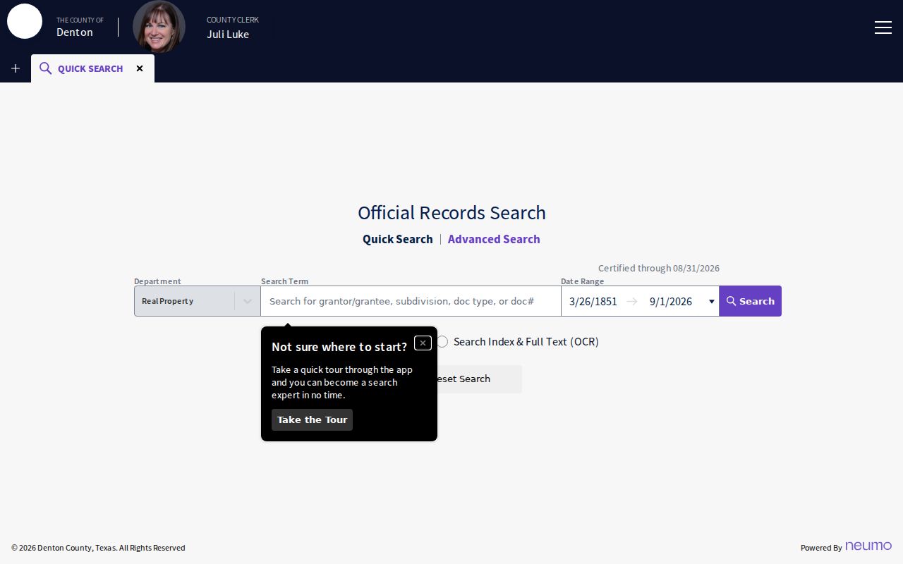
The PublicSearch screen is useful for building a chronology. Save the search term, date range, instrument number, and whether the search used the index or OCR before moving to the next record.
| Search term | Grantor, grantee, subdivision, document type, or document number. |
|---|---|
| Recorded Date | From and to fields, plus quick date ranges. |
| Search scope | Index only or index with full-text OCR. |
| Document trail | Instrument number, recording date, indexed parties, legal description, and record type where available. |
PublicSearch was observed as certified through August 31, 2026. The older GovernmentOS endpoint had an earlier certification date and should not be treated as the current route. A scan must still be reviewed before an OCR phrase or an indexed party becomes a conclusion.
Denton County’s 1875 Records Loss
Denton County history gives the address trail a real break point. The county was created in 1846, its seat moved to Denton in 1857, and the first courthouse burned in 1875, destroying most early county records. A blank before that fire does not prove that a person or parcel had no history. It shows that the usual courthouse path may be incomplete. Official county history should control over a conflicting local search result that gives the wrong fire year.
For a pre-fire gap, compare surviving tax rolls, probate papers, newspapers, cemetery records, family papers, later deed indexes, and neighboring-county material. Call the result substitute evidence and identify its date and keeper. That wording matters because an estate mention, taxable property, or newspaper notice can support a lead without recreating a lost instrument.
Denton County Previous Residents After Renumbering
An old street number needs its own verification step. Denton historical material identifies a February 1920 address renumbering within an early-1920s grid and paving program. The program used 300-foot blocks and 100 numbers per block, yet the research does not provide a universal conversion table. Compare the old number, street spelling, present situs address, legal description, subdivision or lot, and map placement. Record whether the match is documented, probable, or unresolved.
The City of Denton assigns addresses inside its corporate limits after a plat is filed or when a permit requires an address. Outside a city limit, county GIS and postal verification may carry more weight. A stable legal description can bridge a number change better than a street number alone. Replats and subdivision changes may split a property history into branches rather than one simple line.
Note: Keep owner mailing address, property location, and a historical residence line separate because each answers a different question.
Trace Denton County Previous Residents Through Deeds
To follow a chain backward, first anchor the parcel, not a name. The Denton Central Appraisal District schema identifies a property ID, owner and mailing fields, complete situs, legal description, subdivision, block or lot, values, and property-value year. The Tax Assessor-Collector search also distinguishes owner address from property location. That distinction prevents an absentee mailing address from being presented as a historic residence. Once the legal description is stable, use it with the recorded instruments.
- Find the modern situs and property ID through Denton Central Appraisal District, then record the legal description and property-value year.
- Search PublicSearch for the present title party, legal-description terms, subdivision, or known document number.
- Open the purchase instrument and copy its date, document number, grantor, grantee, type, and legal description.
- Search the earlier party and repeat the process, retaining deeds, releases, liens, plats, easements, and probate transfers as distinct record types.
- Move to microfilm or a custodian request when the online path ends, recording the reel, volume, and page consulted.
- Grantor and grantee
- The grantor transfers an interest; the grantee receives it. Those roles are fixed to one instrument, not to every date in a property’s history.
- Chain of title
- A dated sequence of title instruments tied to the same parcel or legal description.
- Legal description
- The lot, block, subdivision, abstract, or other formal parcel wording used to connect deeds when an address changes.
A title party can be an estate, trust, lender, company, or nonresident. It is not automatically a past resident. A directory or census provides a separate, dated household layer.
Denton County Previous Residents on Deed Microfilm
Older Denton deed work has a specific fallback. The Texas State Library catalog notes direct deed indexes for 1875 through 1903 on reels 1302133 and 1303134, and reverse indexes on reels 1303134 and 1302135. The catalog also notes missing volume 61 and that volumes 75 and 78 were not filmed. Those limits should appear in a research log. Check both the direct and reverse index because the direction of the party search changes the path into the deed books.
Texas State Library guidance separately lists deed records from 1854 through 1902 and indexes. The years overlap but do not erase the courthouse-fire issue or the reel gaps. A good entry records index direction, reel, volume, page, spelling used, and the exact legal-description wording. When the source is incomplete, label the link in the chain as unresolved rather than forcing a match.
Denton County Past Residents in Directories
Deeds trace title. Directories and census records help trace past residents. The 1936 Denton directory sample can list a name, spouse or household name, occupation, institution, residence, and an owner marker. Its printed asterisk means no children under 18, and its O or Owr notation indicates an owner for that volume. A printed address supports an association in that directory year, not a claim that every listed person remained there or owned the parcel.
The digitized 1936 directory entry is a useful example of the field-level detail to preserve before comparing years.
The original scan is the authority for spelling, short forms, and ownership marks. The historical collections themselves are described in more depth on the Denton County city directory page.
- Start with the earliest directory or telephone book that names the address or household.
- Compare the next available directory and keep each address form exactly as printed.
- Use a library workstation to pair the period with the nearest available federal census through 1940.
- Test a disappearance with the local obituary index, cemetery material, newspaper microfilm, probate, or a later deed.
Lawful use. Denton County house-history research is for personal, family, heir, and local-history questions. Do not use dated records to harass, stalk, or target a living person.
Denton County Previous Residents on Historic Maps
A digitized 1912 Denton map item can connect a directory street to its older layout. Historic maps and Sanborn material can show a street pattern, footprint, use, or number context when a particular sheet covers the property. They cannot establish ownership or prove who lived at an address. The research did not locate one complete official list of Denton Sanborn years, so identify every item by its own date and edition.
The map image belongs beside the parcel and directory evidence, not in place of it. Compare its street form with the legal description and the 1920 address change before drawing a conclusion.
Denton County Previous Residents Beyond Deeds
Denton Public Library’s house-property guide adds several local layers: deeds, plats, tax records, permits, directories, newspapers, maps, and appraisal information. It notes that the City holds thousands of historic permit cards with building and lot information. Ask Special Collections with the address, legal description or lot, and approximate year. The research did not establish a full date range or a sample permit card, so do not assume every era is available.
For early people and places, the County History & Culture Research Room is onsite. It lists weekday hours of 9 to 4 and Saturday hours of 11:30 to 2:30, recommends appointments, asks for advance notice for special collections, and stops pulls in the final half hour. It can add cemetery, burial, local-guide, and family-paper context when a parcel trail needs another dated source. Keep each source’s role clear: a permit may date a building event, while a directory, census, or obituary may support a household connection.